_ PAGE 1 – Germany – 4 photos
Photo 1: A man and a woman, possibly husband and wife in their late thirties to mid forties, are sitting outdoors at a table, in front of a house (their home?) with a white stucco wall. There is a nice table cloth showing folkloric scenes, maybe Bavarian dancers. The man is wearing the German uniform; the man is sporting the Reiterabzeichen in Silber (silver equestrian badge) on his uniform. The woman is neatly dressed with a crisp white shirt and a dark jacket and smiles as she looks towards the man. They are sipping white wine. There are three glasses on the table so it would seem that the third person is taking the picture. For the purpose of recognizing him, I will call him Man #1. This man is seen predominantly throughout the photo album and might have been the owner of the album.
Photo 1: A man and a woman, possibly husband and wife in their late thirties to mid forties, are sitting outdoors at a table, in front of a house (their home?) with a white stucco wall. There is a nice table cloth showing folkloric scenes, maybe Bavarian dancers. The man is wearing the German uniform; the man is sporting the Reiterabzeichen in Silber (silver equestrian badge) on his uniform. The woman is neatly dressed with a crisp white shirt and a dark jacket and smiles as she looks towards the man. They are sipping white wine. There are three glasses on the table so it would seem that the third person is taking the picture. For the purpose of recognizing him, I will call him Man #1. This man is seen predominantly throughout the photo album and might have been the owner of the album.
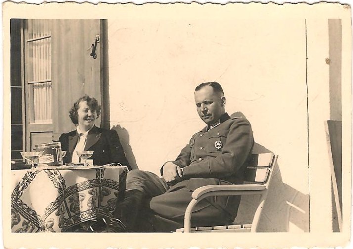
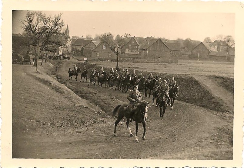
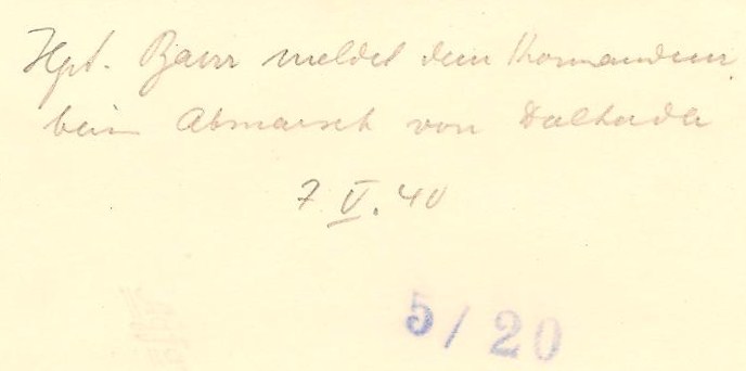
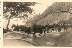
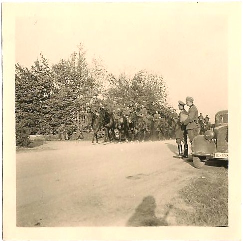
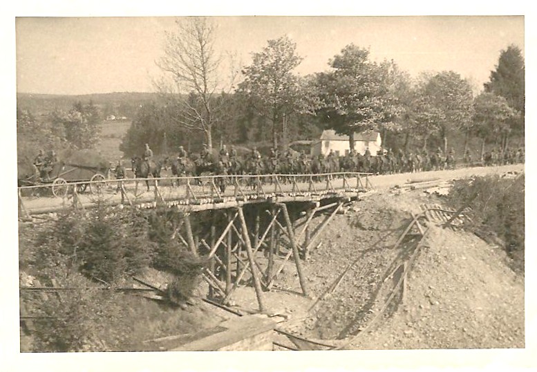
Photo 2: 7th of May 1940 - German soldiers on horseback are coming down a dirt road. In the front, an officer has turned his horse sideways. In the background, we see houses, some made out of wood, a church spire appears behind the houses, more men are attending to horses. Some wagons are parked on the side. A few trees with no leaves on them. On the back of the picture, it is handwritten: Hpt. Baur meldet dem Kommandeur beim Abmarsch von Dalherda. 7/V/40 (Hauptmann Baur reports to the commander on leaving/departing Dalherda).
'Baur' is an alternative spelling of the general family name 'Bauer', a sub-form common in Southern Germany.
Dalherda is a village in Hesse just north of the Wildflecken military training ground, until 1967 it was actually on the training ground but was exempted then. Wildflecken training ground stretches across the border of Hesse and Bavaria (Prussia and Bavaria then), most of it was and is on Bavarian territory.
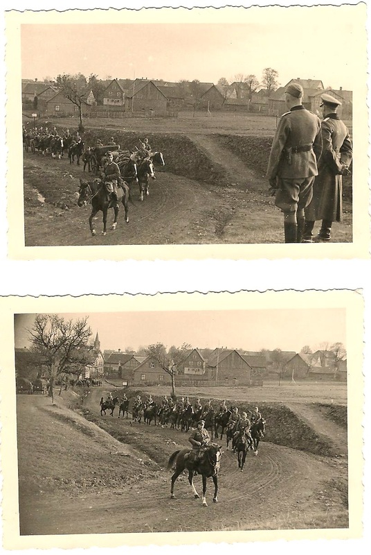
Photo 3: Shows a wider angle of the houses, barracks, men on horses going by; on the right, two men are seen from the back looking down at the cavalry, one has a long coat and a cap on, probably the Kommandeur. On the back, it is written: Abmarsch Dalherda Mai 7, 1940 (Leaving Dalherda, May 7th 1940).
Photo 4: Shows a mountainous region, trees with leaves, the horses are stopped on the road, the men are down, holding them; it looks like they are taking a break.
'Baur' is an alternative spelling of the general family name 'Bauer', a sub-form common in Southern Germany.
Dalherda is a village in Hesse just north of the Wildflecken military training ground, until 1967 it was actually on the training ground but was exempted then. Wildflecken training ground stretches across the border of Hesse and Bavaria (Prussia and Bavaria then), most of it was and is on Bavarian territory.
Photo 3: Shows a wider angle of the houses, barracks, men on horses going by; on the right, two men are seen from the back looking down at the cavalry, one has a long coat and a cap on, probably the Kommandeur. On the back, it is written: Abmarsch Dalherda Mai 7, 1940 (Leaving Dalherda, May 7th 1940).
Photo 4: Shows a mountainous region, trees with leaves, the horses are stopped on the road, the men are down, holding them; it looks like they are taking a break.
PAGE 2 – 7 photos
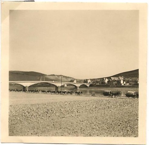
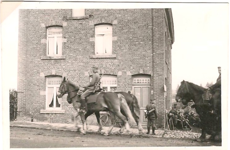
Photo 5: German army at rest in a town square with cobblestones, surrounded by large square buildings about 4 floors high. The men are standing next to the horses and seem to be waiting. The writing on the back says: Mainz – Gonsenheim - 12 V 40 (May 12th 40). Gonsenheim is a district of the city of Mainz. The buildings are the Kathen barracks, used in later years by US forces as Lee barracks.
Photo 6: A line of soldiers on horseback with the Rhine river in the background.
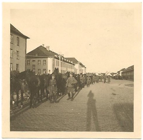
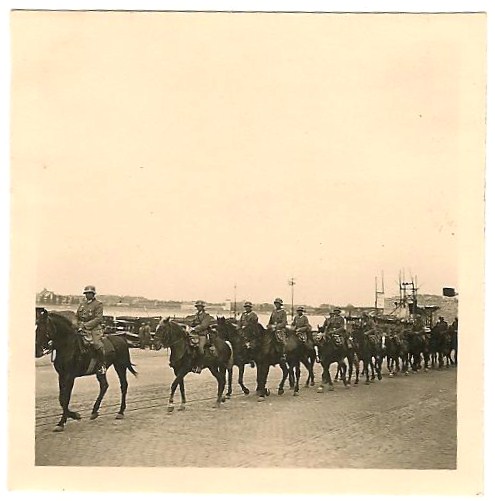
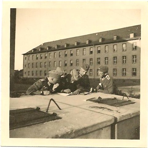
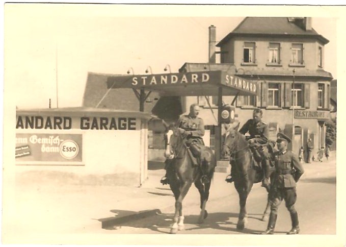
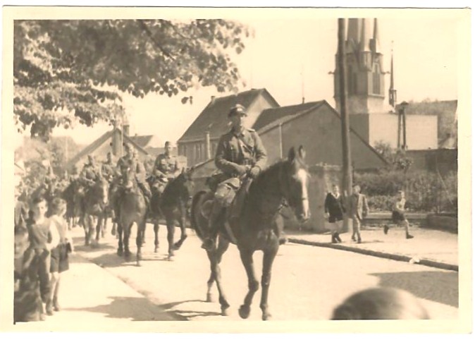
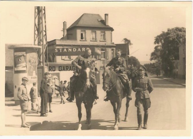
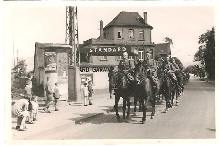
Photo 7: Five men are looking at some maps/documents and one of them is writing something down on the documents. Same buildings in the background. On the back: Gonsenheim – 12 V 40.
See the Google map itinerary.
Photo 8: Three men, two on horses, the third one walking, they seem to be talking, going through a German town, there is a restaurant in the background. They are passing the Standard Garage. The man walking is the commander.
Photo 9: A cavalry going through town, there is an officer (tall with glasses) at the front riding ahead; the sidewalks are filled with children following them. This picture was taken in Gau-Algesheim, 19 km west of Mainz. In the background we can see the tower of the St. Cosmas and Damian church in Gau-Algesheim. See the Google map itinerary.
Photo 10: Another shot of the three men passing by the garage, talking, you can see the street behind them, trees with leaves, there is an open window on a house which would indicate mild weather. The two men on horses are not wearing any hat/cap.
Photo 11: A cavalry going by the same garage. Soldiers look relaxed and some are smiling. Children are looking at them go by. They have all taken off their hats.
www.frankfurt-rhein-main.de/en/Region/Bingen-am-Rhein/Drusus-BridgePAGE 3 – 6 photos
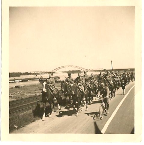
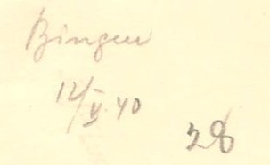
Photo 12: 7th of May 1940 - A cavalry is passing on a massive stone bridge. The bridge is the Drusus Bridge in Bingen. Some large houses on the right, there is a fertile valley with cultivated fields on a vast hill in the back, the top of the hill is treed and there could be some kind of tower at the top of the hill. Text on the back : Marsch über die Nahe 12/IX. 40 (Going over the Nahe River).
The date actually must be May 12th, 1940, no matter what the caption says. The writer seems to have been in a hurry. First he wrote 10/IX. 4, then corrected it to 12/IX. 40. But from later pictures we know that the unit was in another location in September 1940 so to fit into the course of events it must be May 12 th 1940.
The cultivated slopes on the opposite side of the Nahe river are vineyards. See the Google map itinerary.
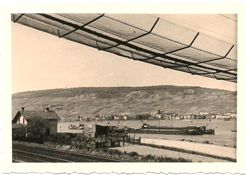
Photo 13: Boats and barges on the Rhine. There is a long steel bridge in the background. The text on the back of the photo says Rhein Bingen. The steel bridge in the background is the Hindenburg Bridge in Bingen. It was dynamited in 1945 and not rebuilt.
Photo 14: Another picture of barges and boats on the Rhine, it seems to be a continuation of the same valley with trees at the top, there is a train track in the forefront, with a house and a fenced garden between the tracks and the river.
Photo 12: 7th of May 1940 - A cavalry is passing on a massive stone bridge. The bridge is the Drusus Bridge in Bingen. Some large houses on the right, there is a fertile valley with cultivated fields on a vast hill in the back, the top of the hill is treed and there could be some kind of tower at the top of the hill. Text on the back : Marsch über die Nahe 12/IX. 40 (Going over the Nahe River).
The date actually must be May 12th, 1940, no matter what the caption says. The writer seems to have been in a hurry. First he wrote 10/IX. 4, then corrected it to 12/IX. 40. But from later pictures we know that the unit was in another location in September 1940 so to fit into the course of events it must be May 12 th 1940.
The cultivated slopes on the opposite side of the Nahe river are vineyards. See the Google map itinerary.
Photo 13: Boats and barges on the Rhine. There is a long steel bridge in the background. The text on the back of the photo says Rhein Bingen. The steel bridge in the background is the Hindenburg Bridge in Bingen. It was dynamited in 1945 and not rebuilt.
Photo 14: Another picture of barges and boats on the Rhine, it seems to be a continuation of the same valley with trees at the top, there is a train track in the forefront, with a house and a fenced garden between the tracks and the river.
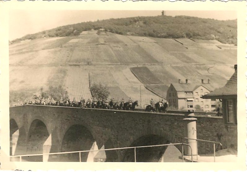
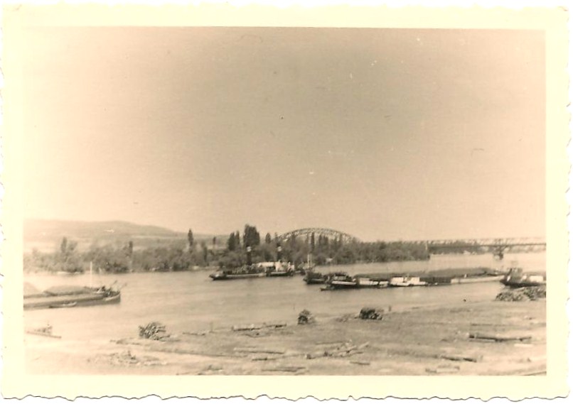
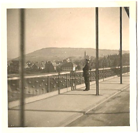
Photo 15: A man dressed like an officer is looking at the river. There is a town and a hill in the background. The text on the back: Rhein (Rhine).
Photo 16: Smiling troops are going through a hilly village; there is a massive stone tower from an old fort in the background and low mountains in the back.
Photo 17: Cavalry going along the Rhine. Also a smiling man on a bicycle riding along. The two horsemen at the front are the same men than on photo #8, same horses. There is a big steel bridge going over the river in the background. This is the Hindenburg Bridge in Bingen. It was dynamited in 1945 and not rebuilt. On the back: Bingen - 12/V. 40.

PAGE 4 – 9 photos
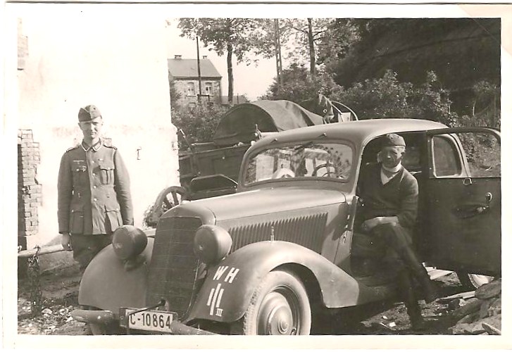
Photo 18: First view of a car. It has an insignia on the back, one long vertical line between 2 shorts vertical lines, III on the right of the lines, WH at the top. WH stands for Wehrmacht - Heer. The Heer was the Army land forces component of the German armed forces (Wehrmacht) from 1935 to 1945. The III means third batallion. The 3 vertical lines mean Artillery. Text at the back: Moseltal – Mai 1940 ( Valley of the river Mosel, May 1940).
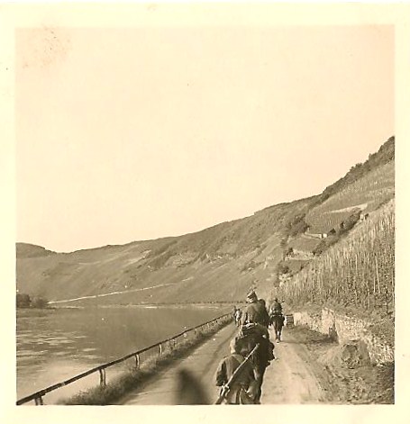
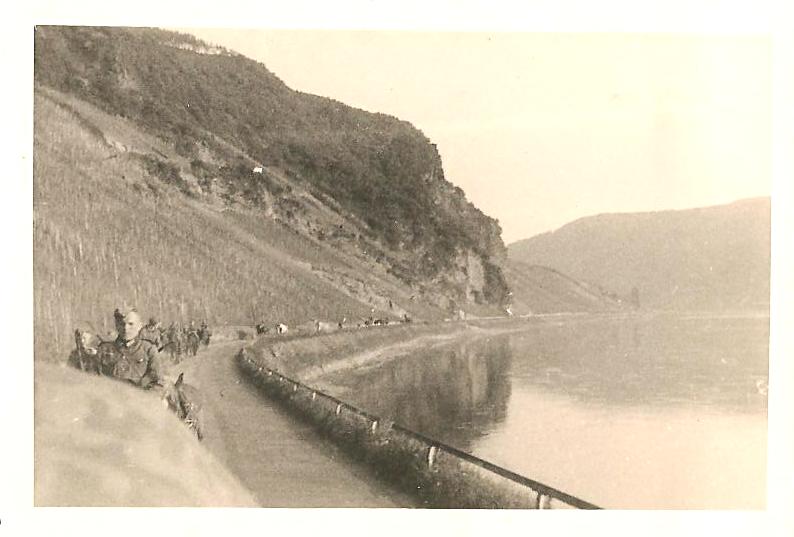
Photo 19: Near Kröv. On a country road surrounded by a forest, the cavalry goes by, there are children on their bicycles watching them and on the left, a band with a large brass section is playing.
Photo 20: A man ‘silhouette against the backdrop of a river. On the right a city sign says Kröv - Kreis Wittlich (Kröv - County Wittlich). See Google map itinerary.
Photo 21: In a town, two little girls aged around 8 on a sidewalk are giving drinks in a glass to a soldier on a horse. There is a plate on a wall behind the girls with the letters DAF for "Deutsche Arbeitsfront".
Click here to find out more about the DAF. Text on the back is : Groß - Karben.
Photo 18: First view of a car. It has an insignia on the back, one long vertical line between 2 shorts vertical lines, III on the right of the lines, WH at the top. WH stands for Wehrmacht - Heer. The Heer was the Army land forces component of the German armed forces (Wehrmacht) from 1935 to 1945. The III means third batallion. The 3 vertical lines mean Artillery. Text at the back: Moseltal – Mai 1940 ( Valley of the river Mosel, May 1940).
Photo 19: Near Kröv. On a country road surrounded by a forest, the cavalry goes by, there are children on their bicycles watching them and on the left, a band with a large brass section is playing.
Photo 20: A man ‘silhouette against the backdrop of a river. On the right a city sign says Kröv - Kreis Wittlich (Kröv - County Wittlich). See Google map itinerary.
Photo 21: In a town, two little girls aged around 8 on a sidewalk are giving drinks in a glass to a soldier on a horse. There is a plate on a wall behind the girls with the letters DAF for "Deutsche Arbeitsfront".
Click here to find out more about the DAF. Text on the back is : Groß - Karben.
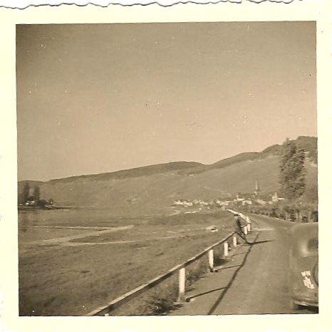
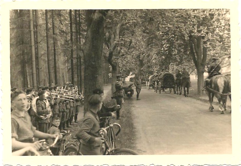
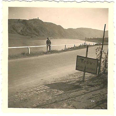
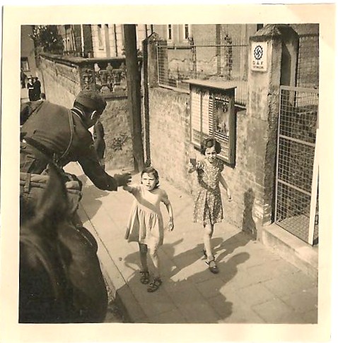
Photo 22: On a country road, two men looking like officers standing next to a car are watching a cavalry go by. You only see part of the plate: IC – 108. The two men look like Man #1 and the commander. In the background, some men are sitting on the ground, probably soldiers resting, near some pine trees. Text on the back: Mosel – Vorbeimarsch der Abteilung (Mosel - Parade of the battalion). The picture was shot at the Moselle river (German Mosel) in the county Bernkastel-Wittlich in Rhineland-Palatinate (Germany).
Photo 23: Cavalry on a road by a river. Hills on the right. Text: Von (From) Kröv, Moseltal. The river left of the riders is the Moselle.
Photo 24: 16th of May 1940. Soldiers along the river. Text: Abmarsch von Kröv – 16 V 40 – Departure from Kröv.
Photo 25: Soldiers on horses along the river.
Photo 26: Cavalry on a road, big stone bridge in the background going over a river with a town on the right. Back says: Zelting – Mosel. Here is a picture of the bridge nowadays (Zeltingen - Rachtig).
See Google map itinerary.
PAGE 5 – 7 photos
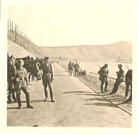
Photo 27: Young soldiers at rest in the countryside, surrounded by trees. About seven of them are standing, with seven more sitting on the ground. The ones sitting have removed their boots (and socks). Text on the back: Fußappell - Mai 40 (Feet roll call (feet control) May 40. I heard of a German veteran who said that they were not given any socks and that their feet would get painfully sore at the end of the day. Some soldiers were given Footwraps.
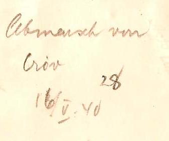
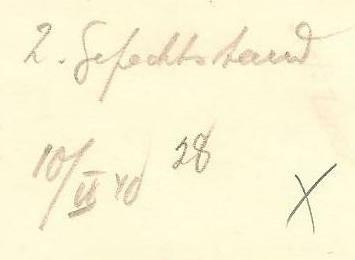
Photo 28: Soldiers are marching along their horses. A few houses in the background. Trees on the right. Field on the left. Text on back says In Deutschland - 28.
Photo 29: Luxembourg border. An officer marches by the traffic-control steel arm that is lifted up. There seems to be a panorama in the background. About eight men are standing; there are a couple of motorcycles and a car.
Photo 27: Young soldiers at rest in the countryside, surrounded by trees. About seven of them are standing, with seven more sitting on the ground. The ones sitting have removed their boots (and socks). Text on the back: Fußappell - Mai 40 (Feet roll call (feet control) May 40. I heard of a German veteran who said that they were not given any socks and that their feet would get painfully sore at the end of the day. Some soldiers were given Footwraps.
Photo 28: Soldiers are marching along their horses. A few houses in the background. Trees on the right. Field on the left. Text on back says In Deutschland - 28.
Photo 29: Luxembourg border. An officer marches by the traffic-control steel arm that is lifted up. There seems to be a panorama in the background. About eight men are standing; there are a couple of motorcycles and a car.
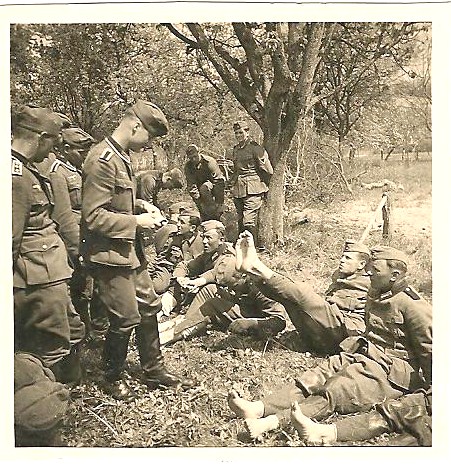
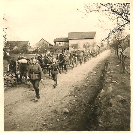
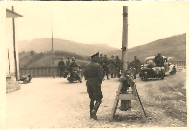
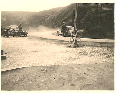
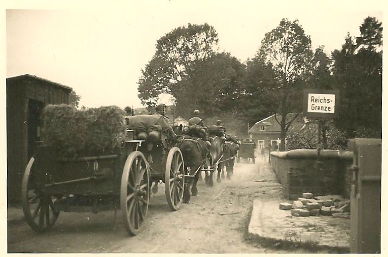
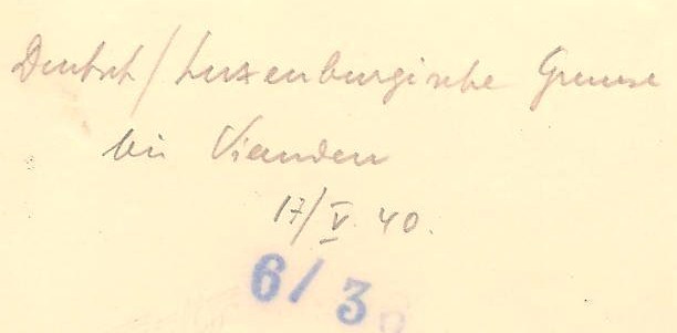
Photo 30: Another view of the steel arm. We see two cars, one man standing by a car, another one standing next to a motorcycle. The text on back says: Luxemburg Grenze Mai 40 (Luxembourg border May 40).
Photo 31: 17th of May 1940. Wagons pulled by horses are making their way through the German-Luxembourg border. Text on back: Deutsch/Luxemburgische Grenze bei Vianden 17 V 40 (German/Luxembourgian border near Vianden).
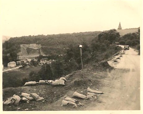
Photo 32: Luxembourg border. There is a deserted road, on the left a vista on a few houses down a hill. In the background, a quarry has scarred the side of the mountain. Down the road, there are two vehicles; a church steeple appears behind the top of the mountain. In the forefront, there are sand bags all along the road. Nobody anywhere. On the back: Grenze Luxemburg – Juli 40 (Luxembourg border - July 40). See Google map itinerary.
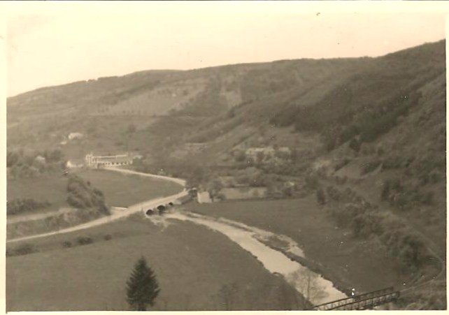
Photo 33: A panorama of Luxembourg countryside with a bridge going over a river and a few houses.
Photo 31: 17th of May 1940. Wagons pulled by horses are making their way through the German-Luxembourg border. Text on back: Deutsch/Luxemburgische Grenze bei Vianden 17 V 40 (German/Luxembourgian border near Vianden).
Photo 32: Luxembourg border. There is a deserted road, on the left a vista on a few houses down a hill. In the background, a quarry has scarred the side of the mountain. Down the road, there are two vehicles; a church steeple appears behind the top of the mountain. In the forefront, there are sand bags all along the road. Nobody anywhere. On the back: Grenze Luxemburg – Juli 40 (Luxembourg border - July 40). See Google map itinerary.
Photo 33: A panorama of Luxembourg countryside with a bridge going over a river and a few houses.
PAGE 6 – LUXEMBOURG – 7 photos
Photo 34: Winding roads through countryside in Luxembourg. Convoy of horses on the road. Text: Luxemburg.
Photo 35: Soldiers on horses through countryside in Luxembourg. There is a broken wagon wheel in the forefront of the picture.
Photo 36: Winding roads through countryside in Luxembourg. Convoy of horses on the road. Text: Luxemburg Mai 40 (Luxembourg May 40).
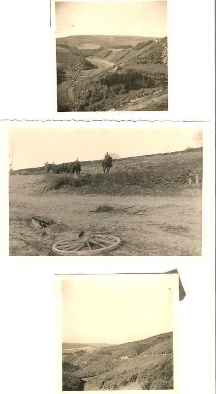
Photo 37: A car is parked in front of an old church. The commander is standing in front of the car looking to his left.
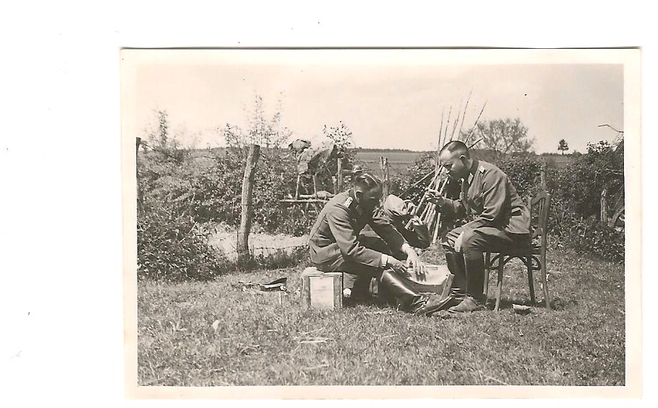
Photo 38: The commander is sitting on a box in a back yard looking over fields. He is eating out of a tin plate placed on a box in front of him. He has removed his cap. See picture # 46 for the same scene with Man #1 sitting across him.
Photo 38: The commander is sitting on a box in a back yard looking over fields. He is eating out of a tin plate placed on a box in front of him. He has removed his cap. See picture # 46 for the same scene with Man #1 sitting across him.
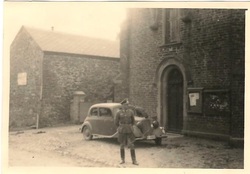
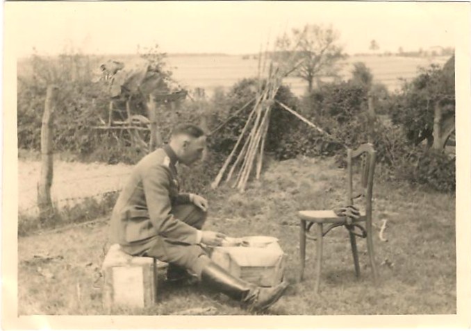
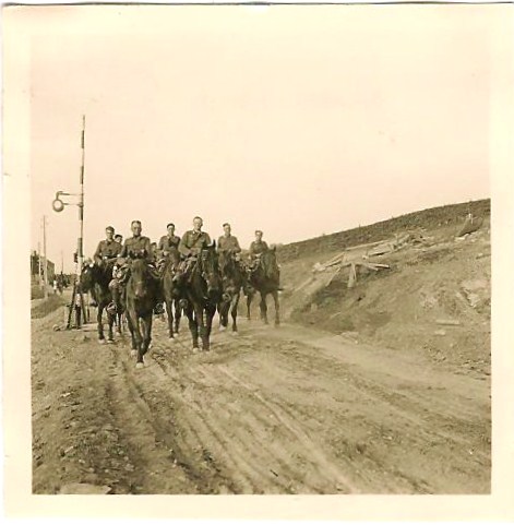
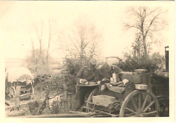
Photo 39: Soldiers on horses on a dirt road. Behind them, we can see the border-crossing check point Luxembourg/Belgium.
Photo 40: Two officers are eating standing up; their tin plates are arranged on the side of the field kitchen.
Photo 40: Two officers are eating standing up; their tin plates are arranged on the side of the field kitchen.
PAGE 7 – Belgium – 7 photos
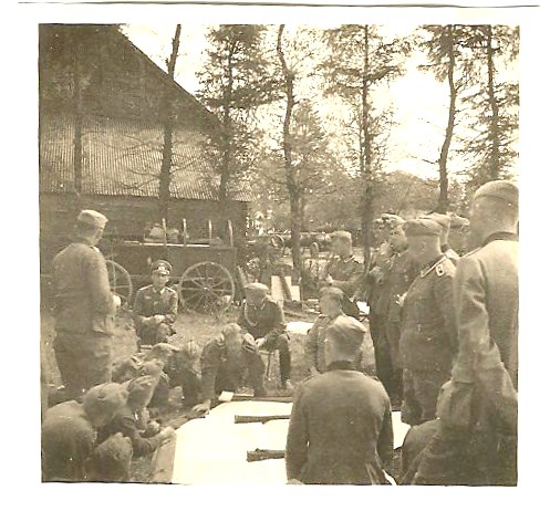
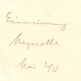
Photo 41: The battalion is at rest in a wooded area. There is a large map on the ground. Soldiers are lying or sitting all around the map. The commandant is sitting on a stool, probably informing the soldiers. The back of the picture says: Einweisung Magerotte - Mai 40 = Briefing at/near Magerotte - May 40. Magerotte is a place in Belgium, located close to the French border.
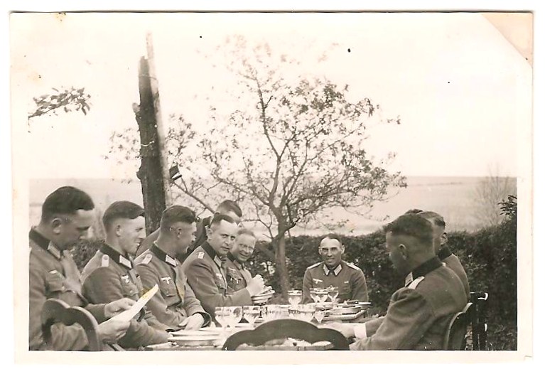
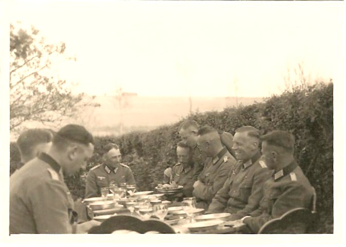
Photo 42: About 10 officers are sitting around a table eating. The commander is sitting at the head of the table. Man #1 is sitting on the left, looking at the camera. They seem to be using their tin plates but there are nice glasses on the table.
In terms of rank, I got some input from the wonderful folks at axishistory.com: One gets the impression from the whole album that the so-called Kommandeur commands an artillery batallion. Batallion commanders were usually Majors or Lt. Colonels. So the lower ranking officers at the sides of the table must be mainly Lieutenants with perhaps one or two Captains between them. In other words, junior officers.
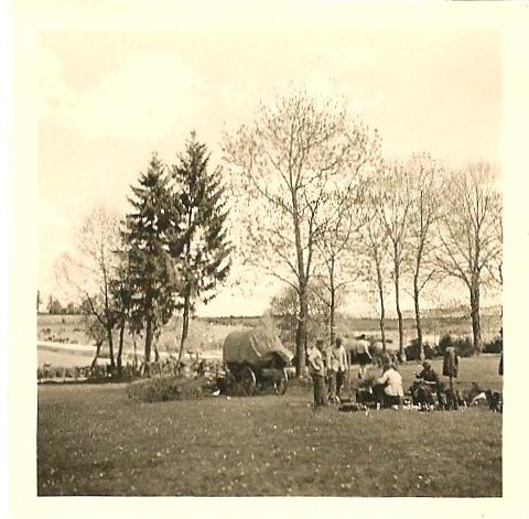
Photo 43: In a field, soldiers at rest, sitting around, talking. Text on the back: Lager Magerotte (Sleeping over or camping in Magerotte). See Google map itinerary.
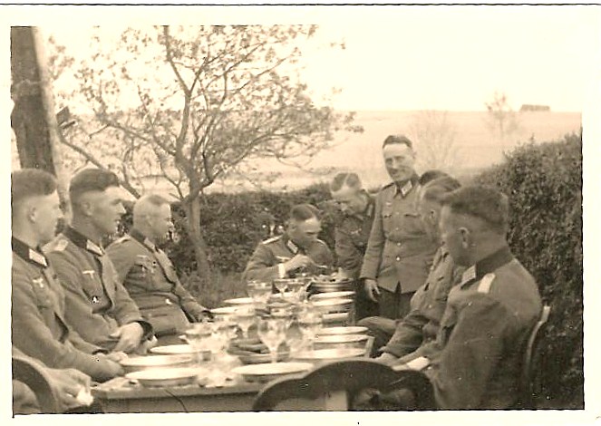
Photo 44 + Photo 45: Another shot of the officers eating.
Photo 46: Goes with picture # 38. Similar picture.
Photo 47: Soldiers on horseback going by a house. A few soldiers seem to be taking a break next to their bicycles on the right of the house.
Photo 41: The battalion is at rest in a wooded area. There is a large map on the ground. Soldiers are lying or sitting all around the map. The commandant is sitting on a stool, probably informing the soldiers. The back of the picture says: Einweisung Magerotte - Mai 40 = Briefing at/near Magerotte - May 40. Magerotte is a place in Belgium, located close to the French border.
Photo 42: About 10 officers are sitting around a table eating. The commander is sitting at the head of the table. Man #1 is sitting on the left, looking at the camera. They seem to be using their tin plates but there are nice glasses on the table.
In terms of rank, I got some input from the wonderful folks at axishistory.com: One gets the impression from the whole album that the so-called Kommandeur commands an artillery batallion. Batallion commanders were usually Majors or Lt. Colonels. So the lower ranking officers at the sides of the table must be mainly Lieutenants with perhaps one or two Captains between them. In other words, junior officers.
Photo 43: In a field, soldiers at rest, sitting around, talking. Text on the back: Lager Magerotte (Sleeping over or camping in Magerotte). See Google map itinerary.
Photo 44 + Photo 45: Another shot of the officers eating.
Photo 46: Goes with picture # 38. Similar picture.
Photo 47: Soldiers on horseback going by a house. A few soldiers seem to be taking a break next to their bicycles on the right of the house.
PAGE 8 – Belgium – France – 9 photos
Photo 48: Soldiers on a dirt road in a wooded area. A sign France/Belgium is in the background. The text on the back: Belgisch - franz.[-ösische] Grenze! Mai 40 (Belgian – French Border! May 40).
Photo 49: Soldiers on a dirt road in a wooded area. A sign France/Belgium is in the background.
Photo 50: Man smoking a pipe on a horse. Text on the back: Dressurakt . Lt. Bader (Teaching lesson, perhaps even dressage show - Lt. Bader). The horse is being trained by Lieutenant Bader.
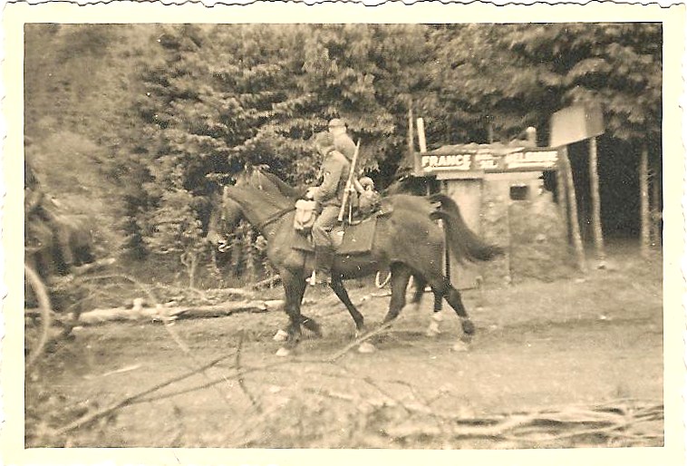
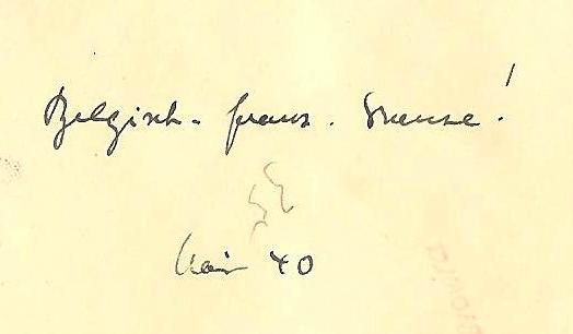
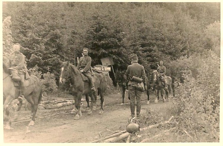
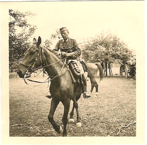
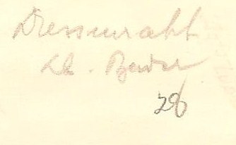
Photo 51: The cavalry has stopped on a country road and the soldiers are standing next to their horses, as if waiting for orders. The commandant is saluting a man who could be a superior. Man #1 is at his side. The text on the back says: Vormarsch! (Advance).
Photo 52: A view from the top. We see a lot of people in a barren, flat piece of land. The back says: Gefangenenlager - Arlon. (Prison camp in Arlon, Belgium). See Google map itinerary.
Photo 52: A view from the top. We see a lot of people in a barren, flat piece of land. The back says: Gefangenenlager - Arlon. (Prison camp in Arlon, Belgium). See Google map itinerary.
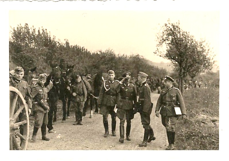
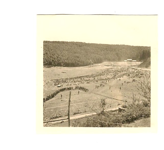
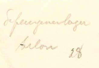
Photo 53: View of a town by a river. There is a broken bridge. This is Nouzonville. The French forces blew up the road bridge but German engineers have already erected two new ones so that the advance can go on. This picture is out of sequence.
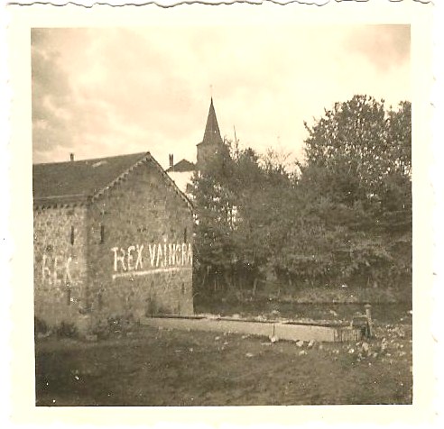
Photo 54: A stone house with graffiti painted on it: REX VAINCRA (The king will win). The text on the back: Belgien – 40 (Belgium - 40).
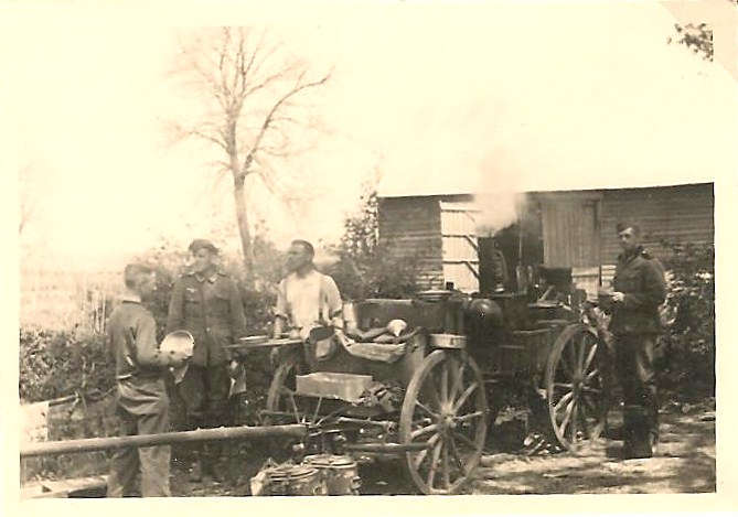
Photo 55: This picture goes with # 40. Another view of the field kitchen with smoke rising. Some soldiers are standing around and there are tin plates and pots here and there. One of the men is wearing a white shirt, maybe the cook.
Photo 54: A stone house with graffiti painted on it: REX VAINCRA (The king will win). The text on the back: Belgien – 40 (Belgium - 40).
Photo 55: This picture goes with # 40. Another view of the field kitchen with smoke rising. Some soldiers are standing around and there are tin plates and pots here and there. One of the men is wearing a white shirt, maybe the cook.
PAGE 9 – France – May 1940 - 5 pictures
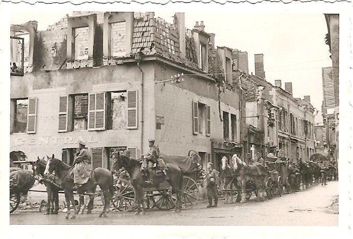
Photo 56: A street, deserted and completely destroyed by bombardments. We can still see the words “Coiffeur” (hairdresser) on the first building left of the picture. Only the facade remains. The stores and houses are reduced to rubble. On the back: Nouzonville – Mai 40.
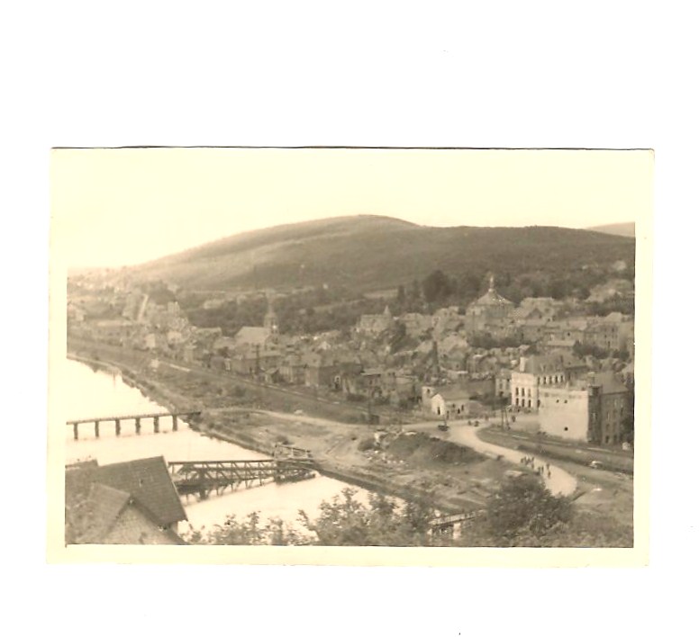
Photo 57: View of the town and the Meuse River. Text on the back: Nouzonville - An der Meuse – Mai 40.
Photo 56: A street, deserted and completely destroyed by bombardments. We can still see the words “Coiffeur” (hairdresser) on the first building left of the picture. Only the facade remains. The stores and houses are reduced to rubble. On the back: Nouzonville – Mai 40.
Photo 57: View of the town and the Meuse River. Text on the back: Nouzonville - An der Meuse – Mai 40.
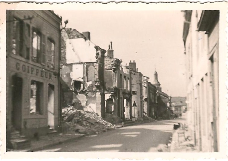
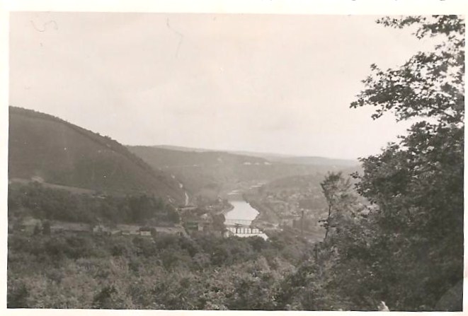
Photo 58: The German cavalry is at rest in the streets of Nouzonville, at an intersection. The corner building was the Hotel Central. The buildings have been bombed and destroyed and the damage can be seen done through windows. Only the facade remains. Text on the back: Nouzonville Ende Mai 40. (End of May, 1940). See Google map itinerary.
Photo 59: Bushy background, looks like a country road. A car is parked. There is also a horse behind the car. The commandant is leaning with his elbow against the car. Three men have their back turned. One of them is operating a radio. Text on the back: Radio beim Vormarsch! (Radio of the advance).
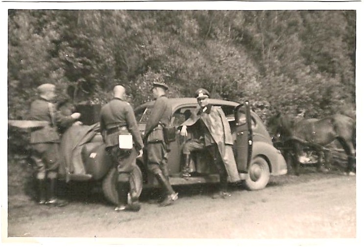
Photo 60: A car is parked in a town. It's a Mercedes-Benz 170 V. A soldier is standing behind the car. An older man is sitting in the passenger seat. He is not wearing his uniform and seems to have a white bandage around his neck from an injury. The car plate reads: IC – 10864. There is an insignia on the right front side of the car with unit marking and the initials WH (Wehrmacht Heer). The tactical sign below 'WH' means 3rd batallion of an artillery regiment.
Heer = Army land forces. Wehrmacht = The German Arm Forces, consisting of the German Army (Heer), Navy (Kriegsmarine), and Air Force (Luftwaffe).
Photo 59: Bushy background, looks like a country road. A car is parked. There is also a horse behind the car. The commandant is leaning with his elbow against the car. Three men have their back turned. One of them is operating a radio. Text on the back: Radio beim Vormarsch! (Radio of the advance).
Photo 60: A car is parked in a town. It's a Mercedes-Benz 170 V. A soldier is standing behind the car. An older man is sitting in the passenger seat. He is not wearing his uniform and seems to have a white bandage around his neck from an injury. The car plate reads: IC – 10864. There is an insignia on the right front side of the car with unit marking and the initials WH (Wehrmacht Heer). The tactical sign below 'WH' means 3rd batallion of an artillery regiment.
Heer = Army land forces. Wehrmacht = The German Arm Forces, consisting of the German Army (Heer), Navy (Kriegsmarine), and Air Force (Luftwaffe).
PAGE 10 – France – May 1940 - 6 pictures
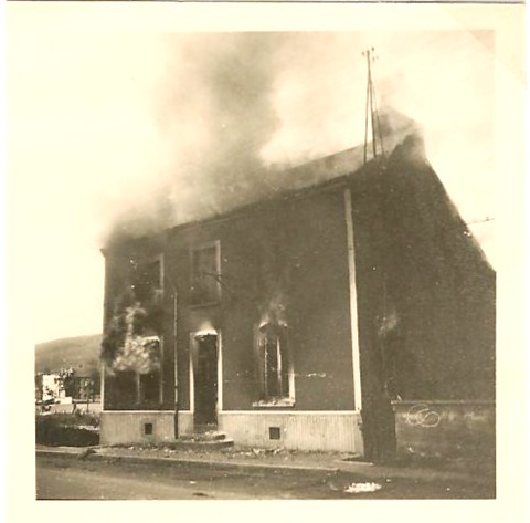
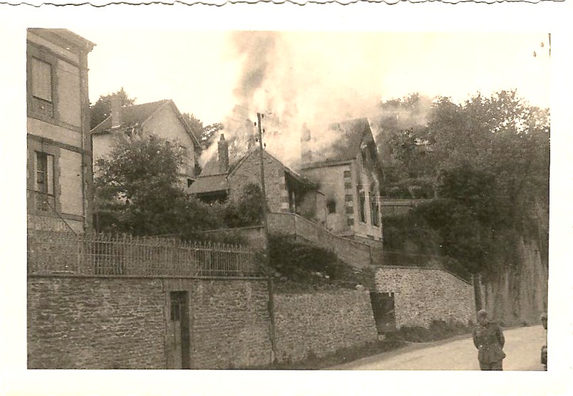
Photo 61: A house has been hit and smoke is coming out of the roof.
Photo 62: Close up of a burning house. Text on the back: Nouzonville.
Photo 63: Same view as # 61 (not displayed)
Photo 64: Same view as # 61 (not displayed)
Photo 65: View from below of a house burning.
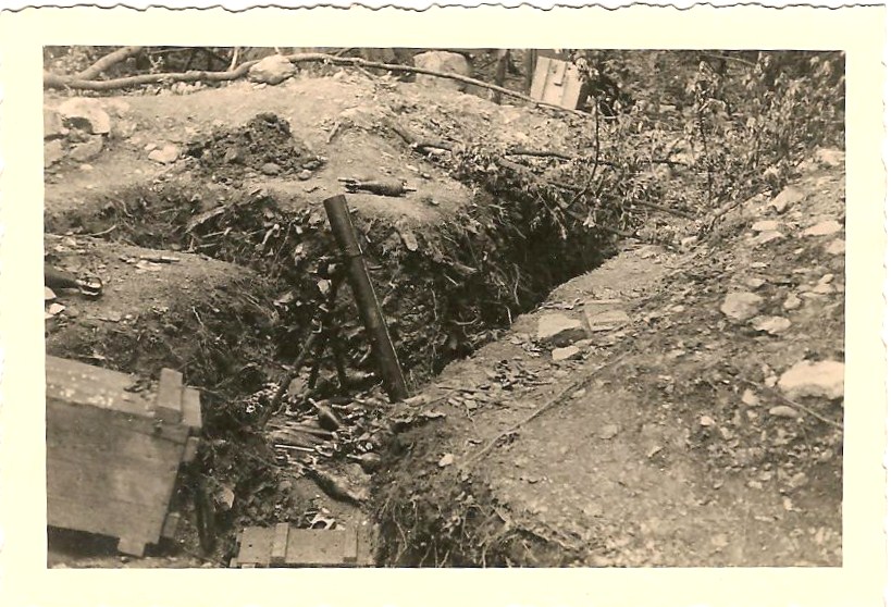
Photo 66: Shows a mortar in a trench. Ammunitions lying around. Could be the one that hit the house (8-cm Granatwerfer 34). It could also be an abandoned French mortar. The 81mm Brandt mortar the French introduced around 1930 was later more or less plagiarized by all other European armies.
Photo 61: A house has been hit and smoke is coming out of the roof.
Photo 62: Close up of a burning house. Text on the back: Nouzonville.
Photo 63: Same view as # 61 (not displayed)
Photo 64: Same view as # 61 (not displayed)
Photo 65: View from below of a house burning.
Photo 66: Shows a mortar in a trench. Ammunitions lying around. Could be the one that hit the house (8-cm Granatwerfer 34). It could also be an abandoned French mortar. The 81mm Brandt mortar the French introduced around 1930 was later more or less plagiarized by all other European armies.
PAGE 11 – France/Libramont (Belgium) - May 1940 - 8 pictures
Photo 67: View of a town, with low hills in background.
Photo 68: At the edge of Nouzonville, a bridge has been destroyed. There is debris all over what’s left of the bridge. There was hard fighting at Nouzonville on May 14 and 15, 1940 when German forces tried to cross the Meuse. Only after other German units managed to cross the Meuse further south at Sedan and further north at Montherme the French gave in and retreated from Nouzonville.
Photo 69: Same destroyed bridge, also in Nouzonville. Beyond the bridge, a large manufacturing building has also been hit and only the facade remains.
Photo 70: Another view of a blown up bridge. There is a low mountain in the background and a town with a church. The church of Nouzonville can be seen in the background.
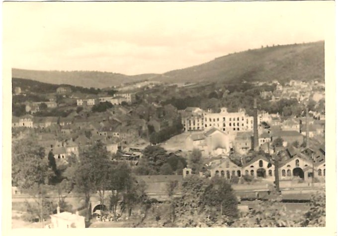
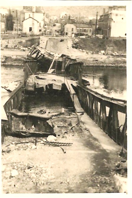
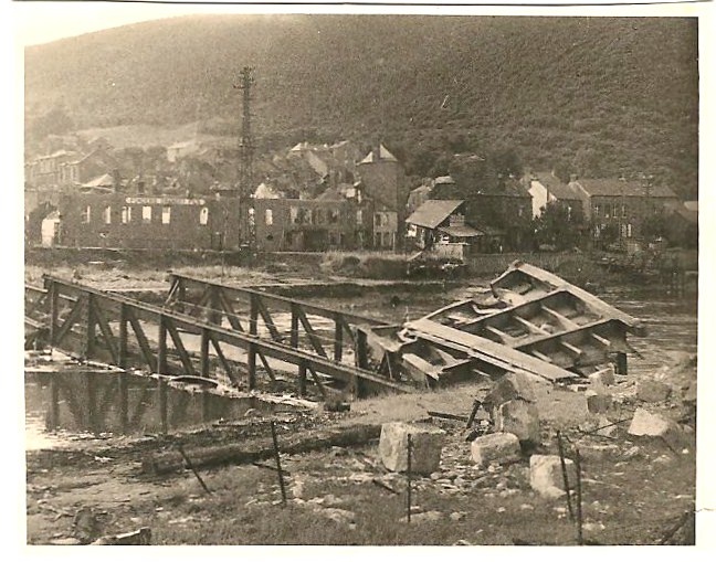
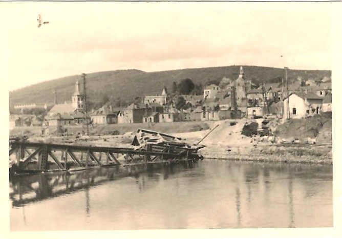
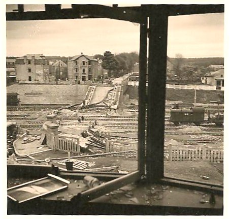
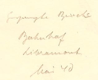
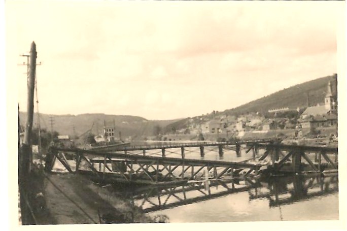
Photo 71: View from inside a building, looking out the window: the railway has been destroyed. There is shattered glass and broken windows inside the building as well. Text on the back: Gesprengte Brücke - Bahnhof Libramont Mai 40. (Blown up bridge - Railway station Libramont. May 40). Libramont is a town in Belgium. The city is nowadays called "Libramont-Chevigny" because it has been agglomarated with the neighbouring village.
Photo 72: Another view of the bridge with the church of Nouzonville in the background. There is a second smaller bridge, still standing up the river.
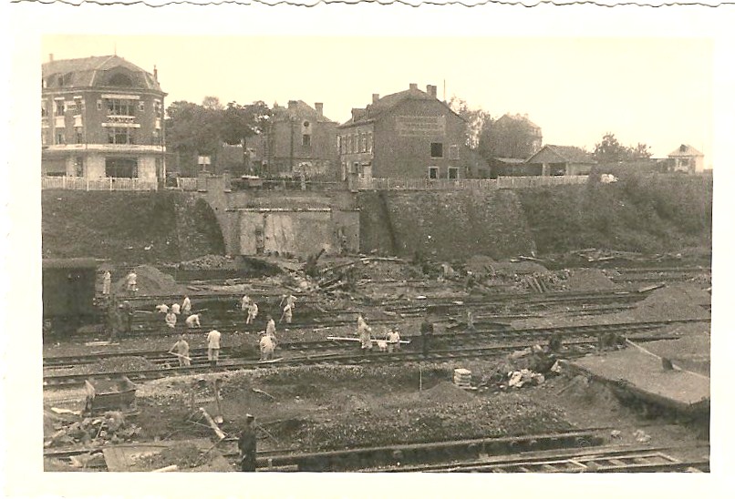
Photo 73: Train station in Libramont. Picture taken from the other side of the railroad line. Men at work, repairing the railway, with a couple of German soldiers keeping an eye on things. See Google map itinerary.
Photo 74: A bridge has been temporarily repaired and the German army is pushing on.
Photo 72: Another view of the bridge with the church of Nouzonville in the background. There is a second smaller bridge, still standing up the river.
Photo 73: Train station in Libramont. Picture taken from the other side of the railroad line. Men at work, repairing the railway, with a couple of German soldiers keeping an eye on things. See Google map itinerary.
Photo 74: A bridge has been temporarily repaired and the German army is pushing on.
PAGE 12 – France – June 1940 - 5 pictures
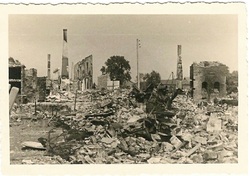
Photo 75: This picture shows complete destruction of a
town. Nothing
recognizable. No
standing building. This is the town of Faisseault. Another view of the town can be seen in picture # 126.
Faissault is a village in the Champagne-Ardennes region of France, close to the Belgian border, between Nouzonville and Amagne. Population in 2007 : 209. See Google map itinerary.
Faissault is a village in the Champagne-Ardennes region of France, close to the Belgian border, between Nouzonville and Amagne. Population in 2007 : 209. See Google map itinerary.
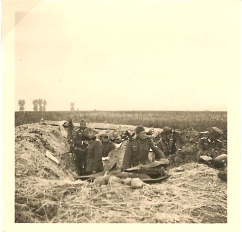
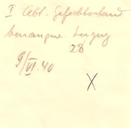
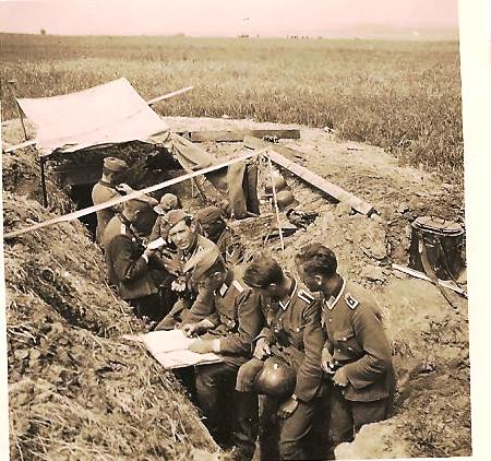
Photo 76: In a field, six soldiers in a trench, looking out. The back says: Abteilungsgefechtsstand (Batallion command post).
Photo 77: Four soldiers in a trench in the middle of a field. The back says: 1. Abteilung - Gefechtsstand, Amagne-Lucquy; 9.VI.40 - (Command post of the 1st Battalion, Amagne-Lucquy, June 9th, 40). See Google map itinerary.
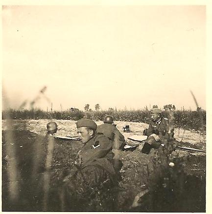
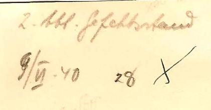
Photo 78: Seven or eight soldiers are standing in a trench. Some of them are looking at some paperwork. There is a makeshift tent at the end of the trench. Same message on the back: 2. Abteilung - Gefechtsstand, 9.VI.40 (Command post of the 2nd Battalion, June 9th, 40)
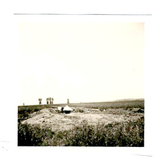
Photo 79: An outside view of the same trench seen from afar. One head is poking out. On the right, there is a thermos container for warm food. Empty fields all around and a few trees on the horizon. Text on the back: 2. Gefechtsstand, 10.VI,40 (2nd command post, June 10th, 1940).
Photo 77: Four soldiers in a trench in the middle of a field. The back says: 1. Abteilung - Gefechtsstand, Amagne-Lucquy; 9.VI.40 - (Command post of the 1st Battalion, Amagne-Lucquy, June 9th, 40). See Google map itinerary.
Photo 78: Seven or eight soldiers are standing in a trench. Some of them are looking at some paperwork. There is a makeshift tent at the end of the trench. Same message on the back: 2. Abteilung - Gefechtsstand, 9.VI.40 (Command post of the 2nd Battalion, June 9th, 40)
Photo 79: An outside view of the same trench seen from afar. One head is poking out. On the right, there is a thermos container for warm food. Empty fields all around and a few trees on the horizon. Text on the back: 2. Gefechtsstand, 10.VI,40 (2nd command post, June 10th, 1940).
PAGE 13 – France – June 1940 - 7 pictures
Photo 80: An open field, littered with holes. There is a town far away in the background. On the back : B' Stellen (Beobachtungsstellen), Amagne-Lucquy, 11.VI, 40 (observation (spotting) posts, between Amagne and Lucquy, June 11th, 40).
Photo 81: Action picture of war. Seven soldiers are shooting the gun. Some of them have removed their jacket and rolled up their sleeves, the one on the left is covering his ear. The noise was so loud that many soldiers lost their hearing from this. The back says: Die 8. Batterie beim Einsatz, am 9.VI.40, an der Aisne (The 8th. battery during an engagement, on June 9th, 40, at the Aisne river).
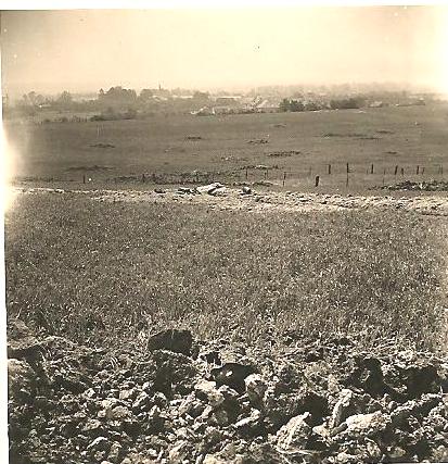
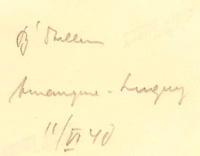
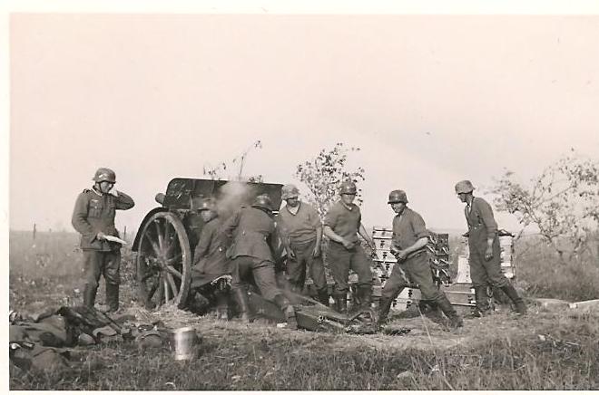
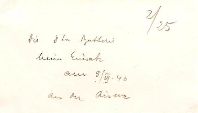
Photo 82: Fairly bad picture of soldiers on a train track. Behind them on the left is a bombed out building painted white with black fire marks around the windows. On the right is a water tower.
Photo 83: Four soldiers walking along a train track. The water tower is in the background. Three of them have their sleeves rolled up. The men are carrying thermos containers with warm food.
Photo 84: This seems to be taking place after the battle. Four soldiers are standing around, three of them have removed their helmets. The gun can be seen in the background, as well as another soldier.
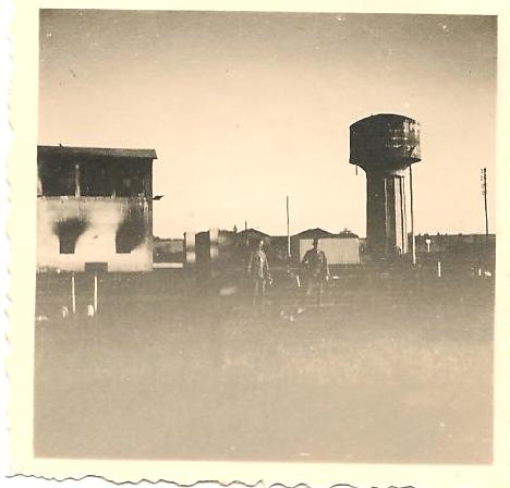
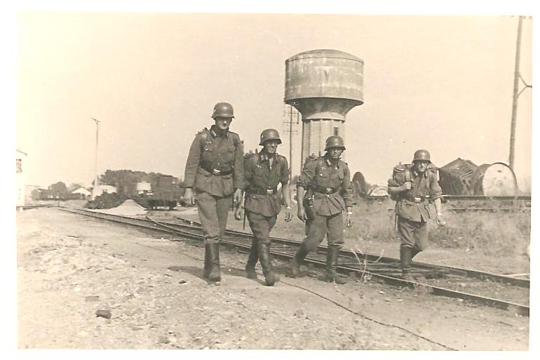
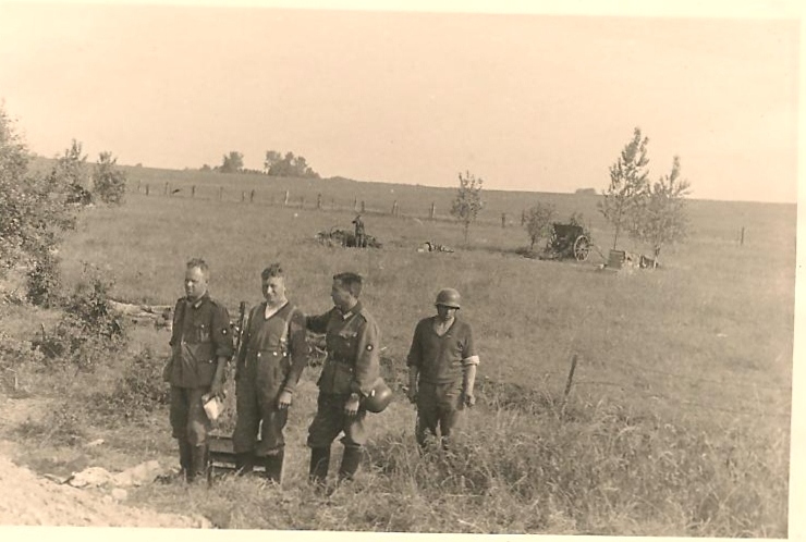
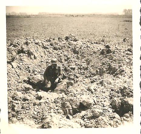
Photo 85: A soldier seems to be crouching in the middle of a disturbed area. His shadow is very dark, indicating a sunny (maybe hot) day. On the back: Granattrichter - Amagne-Lucquy – 12 VI 40. (Granattrichter = Shell-hole)
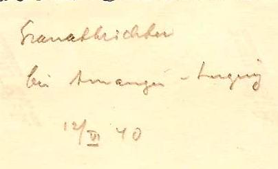
Photo 86: Three men sitting around a trench in a field in a command post. An officer stands in the trench while an NCO works on the radio unit at ground level. On the left there is a machine with cables plugged into it. There is another machine on the right of the men. The man in the middle seems to be wearing sunglasses and is fiddling with something, using his left hand.
Photo 86: Three men sitting around a trench in a field in a command post. An officer stands in the trench while an NCO works on the radio unit at ground level. On the left there is a machine with cables plugged into it. There is another machine on the right of the men. The man in the middle seems to be wearing sunglasses and is fiddling with something, using his left hand.
PAGE 14 – France – June/July 1940 - 6 pictures
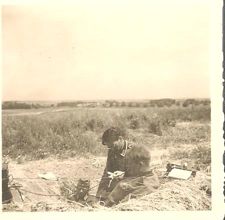
Photo 87: A house has been hit and only a small part of it is standing. You can see the different floors. There are still some furniture left on some floors and even a painting on the wall. A soldier is standing on the street looking up at the mountain of rubble. The back says: Amagne-Lucquy.
Photo 88: A soldier is standing in a fenced field next to a shell-hole. In the background, horses are resting under the shade of some trees; there seems to be a bucket, probably water for the horses. Farther on the right, four soldiers are seen in the field.
Photo 89: Picture of a town seen from above. The back says: Seuil. There's a village called Seuil on the southern bank of the Aisne, just 7 km SW of Amagne. The photo seems to have been taken from a church tower.
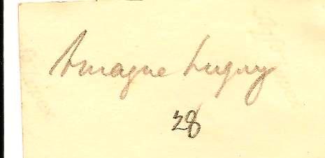

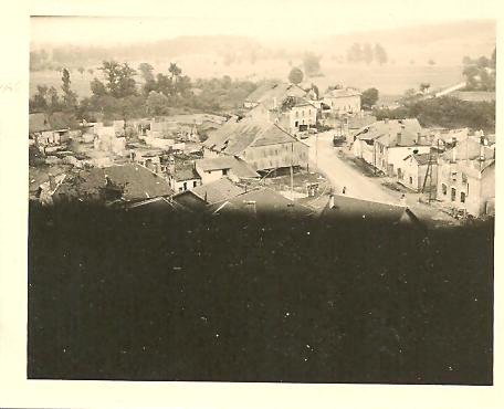
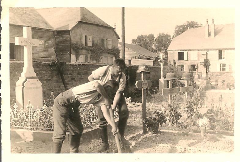
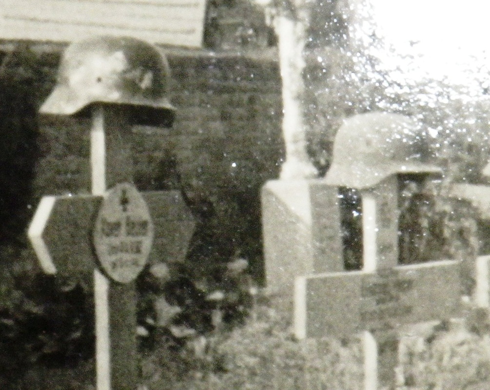
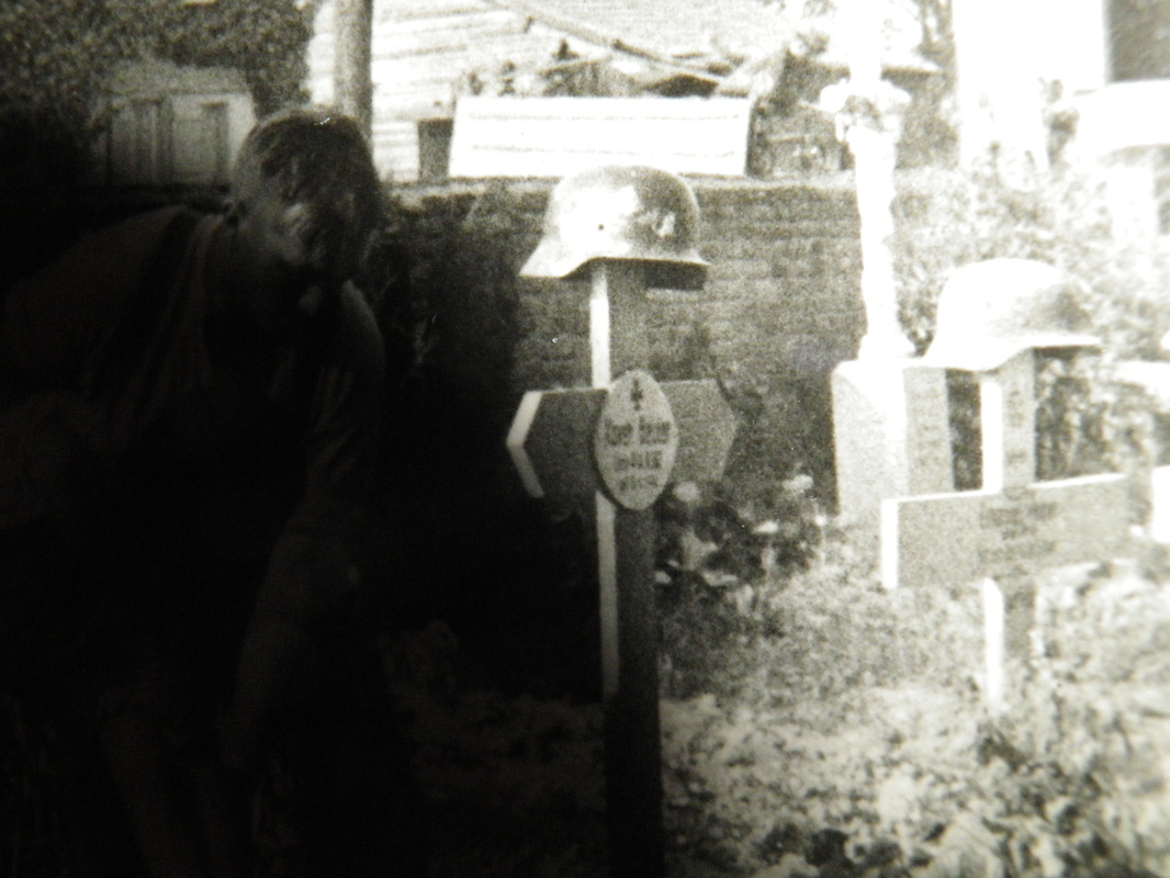
Photo 90: Soldiers are gathered in the Seuil cemetery for a funeral. They have removed their helmets and are holding their heads down. The abutment on the left wall suggest that the cemetery is directly adjacent to the church. See Google itinerary.
Photo 91: Two soldiers are at work with shovels on a grave. They have removed their uniform and are wearing a white T-shirt, sleeves rolled-up. They are wearing suspenders to hold their pants. There are three more graves with the German helmets placed on top of wooden crosses. The higher cross suggests that a high ranking soldier is burried there. The graves are covered with flowers. Warm summer day, the houses adjacent the cemetery have their shutters wide open. Two close-up shots of the name on the grave have been added.
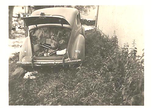
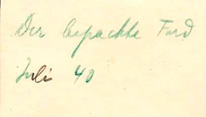
Photo 92: Picture of a car, parked next to a building. The trunk is open and full of things. The back says: Der bepackte Ford - Juli 40. (The packed Ford – July 40). This photo is from July 1940, it should be further behind in the album. The pictures are shown as they appear in the album.
Photo 91: Two soldiers are at work with shovels on a grave. They have removed their uniform and are wearing a white T-shirt, sleeves rolled-up. They are wearing suspenders to hold their pants. There are three more graves with the German helmets placed on top of wooden crosses. The higher cross suggests that a high ranking soldier is burried there. The graves are covered with flowers. Warm summer day, the houses adjacent the cemetery have their shutters wide open. Two close-up shots of the name on the grave have been added.
Photo 92: Picture of a car, parked next to a building. The trunk is open and full of things. The back says: Der bepackte Ford - Juli 40. (The packed Ford – July 40). This photo is from July 1940, it should be further behind in the album. The pictures are shown as they appear in the album.

